The application of Near-Surface Geophysics: Conclusion

[cs_content][cs_section parallax=”false” style=”margin: 0px;padding: 45px 0px;”][cs_row inner_container=”false” marginless_columns=”false” style=”margin: 0px auto;padding: 0px;”][cs_column fade=”false” fade_animation=”in” fade_animation_offset=”45px” fade_duration=”750″ type=”1/1″ style=”padding: 0px;”][cs_text]The conclusion and the results of our 3 part series on the application of near-surface geophysics. You can read part one here, and part two here. OVERLAPPING GEOPHYSICAL SURVEYS To compare the results from each of the […]
The application of Near-Surface Geophysics: Part 2
GEOPHYSICAL METHODS Ground Penetrating Radar For the past 10 years, ground penetrating radar has been the geophysical method most frequently used to profile subsurface conditions at proposed directional drill crossings in western Canada. This popularity stems from the fact that GPR surveys are relatively inexpensive to obtain and large amounts of data can be acquired […]
The application of Near-Surface Geophysics: Part 1
[x_custom_headline type=”left” level=”h2″ looks_like=”h3″ accent=”true”]Near-surface geophysics at proposed pipeline river crossings: a comparative overview of various techniques and their associated capabilities and limitations.[/x_custom_headline] This is part 1 of our three-part series on the application of near-surface geophysics at proposed pipeline river crossings. Abstract The cost, design, and in some instances, feasibility of directional drilling large […]
Induced Polarization (IP) What Is It?

Induced Polarization (IP) is a geophysical method used extensively in mineral exploration and mine operations. The IP survey is very similar to electrical resistivity tomography (ERT). Resistivity and IP methods are often applied on the ground surface using multiple four-electrode sites. In an IP survey, in addition to resistivity measurement, capacitive properties of the subsurface […]
Sub-Bottom Marine Profilers (SBP)
Sub-bottom marine profiler (SBP) is a geophysical method which is specifically designed to detect and characterize layers of sediment or rock beneath a body of water. SBP provides continuous seismic reflection profiles in real time by the use of an acoustic wave generating source and an array of hydrophones to receive the energy reflected by […]
Seismic Reflection What is it?

Seismic Reflection (both on-shore and marine) is the most common geophysical methodology used for oil and gas exploration and exhibits the highest degree of technical sophistication in terms of both data acquisition and signal processing capabilities. Seismic reflection surveys provide either 2 or 3 dimensional imagery of stratigraphic boundaries and geologic structure (e.g. faults, stratigraphic […]
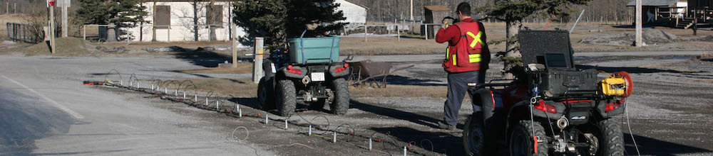
Electromagnetic Surveys – Getting All The Data
Electromagnetic (EM) surveys consist of using either time-domain or frequency-domain electromagnetic field generating systems to measure and map changes in the electrical/magnetic properties of the shallow subsurface. For shallow site investigations, EM methods are commonly used to map variations in either soil properties or to detect and map the location of buried man-made objects or […]
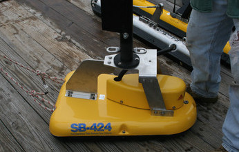
Ground Penetrating Radar
Ground Penetrating Radar (GPR) is a general term to describe methods that use radio waves to probe subsurface objects or geologic features. GPR is a non-invasive electromagnetic (EM) geophysical technique for subsurface exploration and characterization. Using radar principals, GPR systems transmit impulse electromagnetic energy (i.e. radio waves) into the ground and detect echoes, or reflected […]
Electrical Resistivity Tomography What is It?
Electrical Resistivity Tomography (ERT) is an advanced geophysics method used to determine the subsurface’s resistivity distribution by making measurements on the ground surface. ERT data are rapidly collected with an automated multi-electrode resistivity meter. ERT profiles consist of a modeled cross-sectional (2-D) plot of resistivity (Ω·m) versus depth. ERT interpretations, supported by borehole data or […]
Seismic Refraction What is it?
Seismic Refraction (SR) is a surface geophysics method that utilizes the refraction of seismic waves on geology layers and rock/soil units to characterize subsurface geologic conditions. The method involves a geophysical principle governed by Snell’s Law, which is a formula used to describe the relationship between seismic wave angles of refraction when passing through a […]