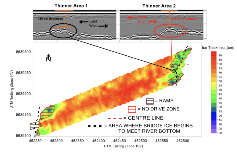
GPR Ice Mapping
GPR Ice Thickness Profiling
Hazard Identification
Project personnel and equipment falling through ice due to ice cover weight overloading and subsequent failure. Potential for serious injury (e.g. hypothermia) or loss of life. Potential for severe/costly equipment damage. Potential for environmental damage and costly clean-up operations.
Working, travelling, and parking on the frozen surface of ponds, lakes, and rivers should be undertaken as planned activity that recognizes and addresses the hazards associated with the ability of the ice cover to safely support the load. Ice road operators, employers, constructors focus on advice that provides effective over-ice operations while insuring that a standard of care necessary to protect worker safety is the highest priority. Extensive use of Dr. Lorne Gold’s formula published in “Use of Ice Covers for Transportation” (1971) forms the basis for published ice capacity guides.
Gold’s Formula:
P = A x h2
where:
P is the allowable load in kilograms
A is a parameter that depends on the strength of the ice
h is the effective thickness of good quality ice (cm).
Assessing maximum ice bearing capacity of the ice cover is based on two variables: 1) Ice Quality and 2) minimum thickness of ice cover within the confines of your work area.
Best Practice for Ice Cover Assessment in your Project Area
For over 30 years Ground Penetrating Radar (GPR) ice surveying has become the most common method to obtain ice thickness profile information over large areas or distances. GPR surveys over ice cover work or transportation areas offer the best non-destructive means of obtaining the density of ice thickness measurements needed to provide the best possible standard of care for worker and/or public safety.
Do you need Qualified Professional GPR Services for Assessing Ice Thickness on your Project?
Surface Search offers a full host of Ice Thickness Mapping Services for Ice Road Operators, Constructors and Employers. These services include:
- GPR Data Collection (Single or Dual Channel)
- Ice Thickness
- River Bed Elevation
- Safe work plan preparation and monitoring services for all ice assessment / survey operations
- Ice auger measurement services (for ice quality assessment and GPR velocity calibrations / quality control)
- Integrated DGPS Survey Control / Reference of all acquired GPR measurement data and auger hole locations
- Calculation of Ice Bearing Capacity for your Project
- Demarcation of Optimal Transportation Route Pathway to Avoid Thin Ice Areas Identified by Professional GPR survey.
- Next Day Reporting of GPR Results
- Professional Standard of Quality Control and Care in all aspects of GPR Data Acquisition and Analysis of Results (e.g. NAPEG, APEGA).
Our GPR field technicians are fully qualified, trained, and experienced in remote survey operations in extreme conditions.Free GPR technician and GPR equipment mobilization/demobilization for GPR surveys taking 5 days or longer to complete*
*(some terms and conditions apply)